Ceyhun Atuf Kansu Cad. 1262 Sok. 1/9 Ankara/Türkiye
+90 312 474 0 474
info@satlab.com.tr

SLS-1
Mobil Lazer Tarayıcı

Mobile Laser Scanner System for 3D Mapping

SATLAB Geosolutions

Mobile Laser Scanner System
for 3D Mapping

SATLAB Geosolutions

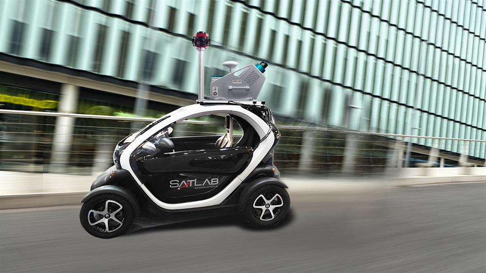
Satlab SLS is a Mobile Laser Scanning System solution using a fusion of sensors providing location, imagery and point cloud.

SATLAB Geosolutions

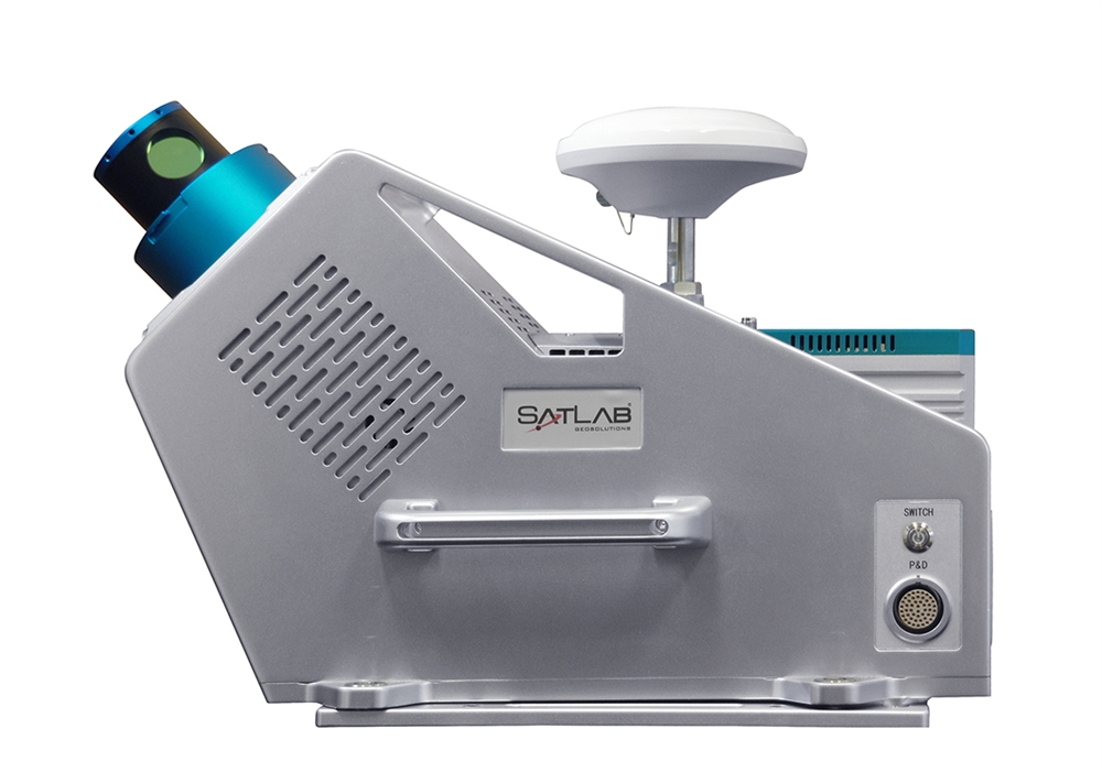
Satlab SLS is configurable by accommodating available high end sensors through a state of the art Sensor Fusion module which controls and synchronizes data streams from the sensors.

SATLAB Geosolutions

A tactical grade iMAR FSAS IMU by Novatel GPS, ensures the highest accuracy in the harshest environmental conditions.

SATLAB Geosolutions

Two MDL 500m long range low density LiDAR sensors and one Velodyne 100m short range high density laser sensor provides the best possible point cloud coverage. Spherical imagery is provided by the on board LadyBug 5 camera system.

SATLAB Geosolutions

SATLAB SLS contains an embedded computer to log the data streams from all sensors together with time stamps thus ensuring no data can be lost during field operations due to cables or operator issues.

SATLAB Geosolutions

The integrated mounting structure makes it possible to use on any moving platform from off-road vehicles, to a train or small boat, to a personal car; all can easily be used as the scanning platform.

SLS-1
Mobil Lazer Tarayıcı

General

– Type: Integrated mobile laser scanner
– Temperature Range: -10°C – +45°C
– Vehicle Speed: 30-60 Km/h

Sensor Technical Specifications

– Distance Measurement Mode Pulse: 1545nm
– Laser Classification : Class 1 (Safe for human eye)
– Laser Pulse Repetition Rate : 500kHz
– Minimum Measurement Range : 1.5m
– Maximum Measurement Range : 650m
– Range Measurement Accuracy : 4mm(@192m, ρ = 60%)
– Repeatability Precision : 6mm(@192m, ρ = 60%)
– Maximum Scan Speed : 200Hz
– Angle Measurement Resolution : 0.0088°
– Field of View : 360°
– Data Transmission Interface : Giga Ethernet
– External Time Synchronization : PPS,GPRMC
– Operation Voltage : 24V DC
– Power Consumption : <100W
– Main Dimension : 304mm×191mm×169mm
– Weight : Approx. 6.1Kg
– Operation Temperature : -20~+55℃
– Storage Temperature : -40~+65℃

Positioning Accuracy

– Type : “Tactical Grade” Inertial System with tightly coupled GNSS integration – – Accuracy GNSS Sensor : NovAtel OEM 617
– GNSS Accuracy : 5mm+1ppm RMS
– IMU Sensor : KVH 1750
– IMU Accuracy : Roll: 0.005 (Deg. RMS), Pitch: 0.005 (Deg. RMS), Heading 0.017 (Deg. RMS)

Distance

– Distance Measurement Indicator (DMI): Available

RGB Camera

– Type : Industrial Spherical Camera
– Sensor : Ladybug 5
– Resolution : 6 x 5MP (30MP)
– Field of View : 90% of Full Sphere

Expansion

– Different configurations available

Medya